
Choquequirao is a place that we have been thinking and dreaming about for quite some time. And I have been walking and hiking a lot specifically to train for this hike--I haven´t been in the greatest shape for long treks, so I didn´t want to mess this one up. After all our preparation, however, the tour began with a big disappointment when Kate got really sick the day previous. She had been sick with a cold for a few days before, but the night before the trek she was still feeling awful and had aquired a stomach bug in addition to the cold. We decided together that I should go on the trek without her because it was already half paid for, and the other people in the tour group depended on a certain number of people to make the trip affordable. Also, I suppose I had been talking about it for so many months that there was no point in having us both lose out. And Kate was in good hands with our host mother Maike and all her family and friends, that I wasn´t too worried.
Choquequirao is one of the difficult-to-reach incan cities, also sometimes known as the last refuge of the Incans. It was one of the last cities to be discovered by europeans, along with Machu Picchu, and had never been discovered or thus destroyed by the Spanish colonists. As the Spanish conquered the Incans, supposedly their last refuge was likely Choquequierao, although the area and its history is still actively being studied. After roads were built to Machu Picchu, Choquequirao is one of the last well-preserved cities of the Incans that is not overrun by tourists. And for good reason: the round trip hike to Choquequirao goes through a mile-deep canyon (one of the deepest in the world, depending on how it´s measured) and is about 50 miles round trip. And that is why it gets about 5 to 20 visitors a day, compared to 5 thousand visitors at Machu Picchu. And because the Peruvian government is supposedly talking about building a tram to Choquequierao (which may just be a pipe dream), it was nonetheless a motivation to go there during our current trip.
The trip begins in a town called Cachora, about 4 hours by bus from Cusco. Although you can just backpack it yourself, or arrange the whole trip in Cachora, due to time limitations we arranged it through an agency in Cusco. They set up a guide, a cook, and a mule driver. We signed up for a special trek of 5 days and 4 nights. Normally the agencies go for 4 days and you only have part of a day to explore the ruins after an excruciating day of hiking. We opted for the extra day so that we´d have a day just for the ruins, since we were not professional hikers. Four of us were on the trek, Vendi and Petra from the Tzech Republic, Tim from Germany, and me. Our guide was named Wilson, the cook was Washington, and the mule driver had a Quechua name that I couldn´t pronounce nor remember. A lot of the local people from around my generation, 30-40 years old, have very american sounding names due to the custom of the times.
Here´s a scene from the town of Cachora, which is composed mostly of adobe buildings with stray dogs, chickens, and pigs wandering the streets:
 Our Mule driver loading up the mules. In all there were 3 mules and one horse.
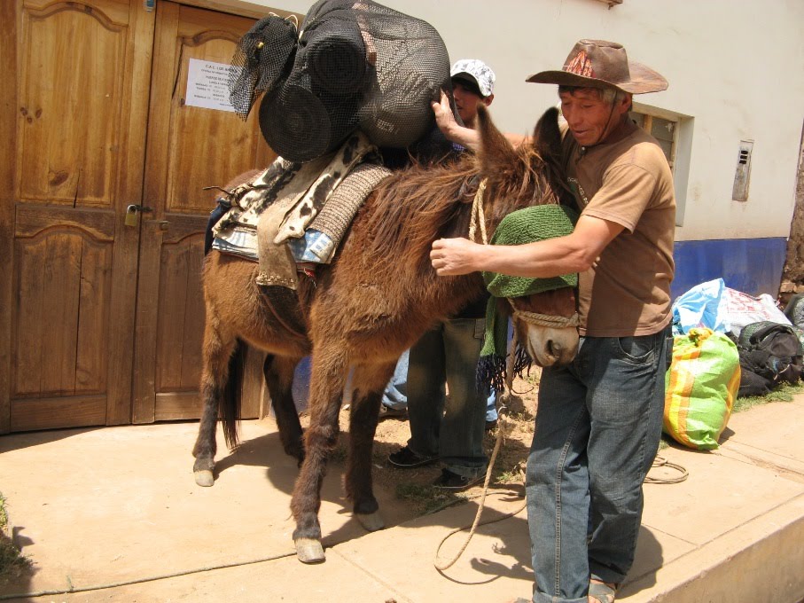 And here they are as we began our trip. The cook was riding the horse here, but most of the trip they both walked. The mule driver walked the whole thing in sandals. These were two amazing people who would get to our camp early, set up tents, cook the meals, and have everything ready by the time us slowpokes got there. Then after we would leave the next morning, they would put everything away, pack up the mules, and leave, passing us tirelessly halfway through our hike on the way to the next campsite. I guess if you do the hike every day, then it gets easier for you and it´s just another day in the office...
Here´s our group the first day on the first lookout of the trail, from left to rigth is Petra, Wilson, Vendi, and Tim. I´m taking the picture of course. That´s the canyon below us that we were preparing to walk through. And of course snowcapped tropical mountains in the background.

An andean condor glided along the winds of the canyon above us, as if to greet us or taunt us as we started our journey:
 And here´s me on the trail.
  Having read other blogs about the Choquequirao hike, I wished that some of them posted more pictures of the trails, and not just the destination. For one thing, I wanted to know how long and how scary the trails would be to see if I could really do it. As some of you may know, I suffer from some vertigo due to heights, and I´m slowly working on doing higher and steeper places. It´s a matter of going a little further and a little steeper each time. This hike definitely challenged my limits. So to remind myself of what I did, and to inform anyone else curious about undertaking the hike, I´ve included a few of the typical views along the trails. Views both breathtakingly beautiful and occasionally vertigo inducing.
  There was also plenty of dust on the trail, especially as a pack of mules passed by:
 Here´s a view from one side of the canyon to one set of switchbacks on the opposite side:
 When you get to the bottom of the canyon, there is a bridge crossing the raging Apurimac River:
 It was quite a beautiful river. The house-sized boulders in the river gave some indication of the size and power of the floods that are possible here:
 And here´s me again on one of the switchbacks down towards the river. I think this was actually the 4th day, but I suppose it doesn´t really matter for the story here. The pictures here are pretty much out of order--I´ve more or less just grouped them by subject matter:
 Lots of these signs to warn of falling rocks. Not that there´s a whole lot you can do about it when you´re on the path.
 Here´s sunset beginning to fill the canyon:
 And here is our campiste for the first and last night:
 The second and fifth days were the most tiring because of distance and altitude. The second day meant dropping a couple thousand feet from our campground to the river, then climbing up switchbacks in the desert sun for about 5000 feet, then a couple more 1000 feet ups and downs to the final campsite, about 10 miles later. Because of the heat at the bottom of the canyon, we started early in the day and reached the top by lunchtime. We were greeted by green pastures and mud-and-bamboo houses around one of the campsites where the cook and mule driver had already set up lunch:
 Here they are cooking for us:
 There was a little girl with puppies who lived with her mom at the campsite. She sat at the table and had lunch with us. And we told her how lucky she was to live in one of the most beautiful places in the world:
 Fast forward a day. We camped out and embarked the next day for Choquequirao, which is spread out over and around a saddle of a mountain a couple miles from we camped. The first place we got to was the temple areas for the incan priests, which was separate from the rest of the site. This picture doesn´t really do the site much justice, but it´s what I have at the moment:
 after walking around the hilltop from the temple, we got a view of the main city part of Choquequirao:
 We set up for a group picture, and afterwards, Wilson gave us a talk on the history of the site, which I will not go into detail here; you can look it up on wikipedia yourself if you´re interested!
 When we got down to the city, it was just our tour group and three other people in another group. They were in kind of a hippie-shaman-like group playing pan pipes and enjoying different local herbs, but their music gave some pleasant andean ambiance to our trip. Other than that, the only other sound was the wind.
 Another view of the city:
 Choquequirao is unusual in that is has some of the few two-story incan buldings around. And above them you could see some snow capped mountains:
 You can kind of see in this picture the aqueduct that comes down the mountain on the left side and through the city. Archeologists and laborers were working on reconstructing it so that it would function again. In the mountains above the city, you could see how the aqueduct cut through a few miles of cliffside to one of the rivers in the distance (not shown). According to our guide, one theory as to why the Incans built cities on such high hilltops was to have access to very clean water. Other theories include ideas such as worship, defense, access to stones, and avoiding dangerous flooding below. It may be a combination of those different ideas that would have convinced the Incans to build cities in such inaccessible locations, but it certainly makes for fun adventures and stories.
 On an extremely steep hillside below the main city are a bunch of terraces, which are famous for their pictures of llamas. I also included a few pictuers of the trail there because it was on my limit of ability in terms of heights.
  One part of the trail connects win the incan staircase on the terraces--one of the less steep parts of the stairway. On our way back, the girls were in front and I was following them up the stairs, with Wilson in the back. We went up further than I remember going down, and pretty soon the staircase was so steep that I was using my hands in front of me to hold on as I was climbing. I was starting to feel dizzy and nauseous and I exclaimed that I didn´t remember it being that steep on the way down. Wilson, behind me, laughed and said it was because we passed the trail and we had gone to far up the stairs. I took a picture from there looking down the stairs into the river a mile below, and I quickly ran back down the stairs to the trail!
 A few other scary switchbacks on the trail:
 Here are the famous llamas. They are built into the terraces with white stones. Some people claim that the terraces are agricultural terraces (as the Incans are famous for), but others claim that this is more of a religious monument or place of worship because of the decorations in the terraces and because of the incredible steepness of them. There are much less steep places to do agriculture around there:
 After returning to the city above, we went to the upper part of the city where we met an archeologist named Denise and one of the helpers who was working on restoring parts of the aqueduct:
 There were some very scenic parts in the upper part of the city, like where the buildings were built up and around giant boulders:
 A view from the other side of Choquequirao. From here you can see the saddle of the mountain, and the hill (on the other side of which is the temple), and also you can see part of the llama terraces with the switchbacking trail nearby:
 A few other beautiful parts of the city:
 And here is the longest terrace in the city, which forms part of the trail back to camp. You walk along this terrace for a long time:
 Did I mention there were biting flies? Well, there were lots of them. The folks here called them mosquitoes, but I knew better. Mosquitoes don´t really bother me all that much anymore, as long as they don´t give me diseases. But these flies, in addition to drinking DEET as a hobby, left little blood blisters with giant welts. Here´s my arm on day 3. By day 5 they had finished all the remaining spots on my arm.
  And here´s Tim and Wilson getting ready for dinner at our campsite near Choquequirao (which is to the left of the last hill at the upper left of the picture:
 OK, by the third day of running up and down hills on our trek and around Choquequirao, my knees were really starting to hurt. I was probably one of the faster in the group at climbing up the steep hills, but when it came to going downhill, my tendons were really starting to ache. Vendi, being a doctor, helped me wrap up my knees in elastic bandages. And on the fourth day, on the trek home, there was one more set of terraces another thousand feet below our campsite. I, sadly, opted to leave early on the trail on the way back, while the others went to the lower terraces. An hour later, I could just barely see them exploring the lower terraces:
 It was a good thing that I didn´t go, however. The rest of the group really enjoyed the terraces, but they said that it was really steep and scary for them--even worse than the llama terraces! I´m not sure I would have been able to handle that. Also, I had a 2 hour head start, and I took it very slow going back down the steep switchbacks. I actually found that walking backward down the hills helped, and I probably walked about 5 miles that day backwards. And when I was not walking backwards, I was using my two hiking poles (thanks Sarah and Bas!) almost like crutches to ease the pressure on my knees. It all paid off in the end because I had almost no knee pain on the 4th day, and we all met up for lunch and at the bridge at the bottom of the canyon at about the same time. For the climb back up to our camsite on the other side, I was perfectly fine to climb up the steep hills.
 Our last night we enjoyed some cool beers at the campsite and like at all our dinners we talked about all the different countries and cultures that comprised our group. Wilson gave us all nicknames in quechua. Mine was something like sapayan soq´ua (Vendi wrote them down so I´ll have to come back later and correct it), meaning the one who left his heart behind. I missed Kate during the trek, and wished that she could have come along, but it was the best we could do. After the final grueling day of 15 miles, dust, mosquitoes, sunburn, and endless switchbacks out of the canyon, I came home to Kate feeling much better and relaxed. And the first hot shower in 6 days. We´re now ready to do our last couple rounds of shopping and visiting Cusco before packing for home. And finally, one last image of one of those scenes that I´ll always remember from South America. Here´s a lady in Cachora leading a horse through town:
 That´s all for now. And if you haven´t been here lately, please notice that Kate has been writing a post at the same time as me, but she finished a little sooner, so the next one that follows also corresponds to our last week or so in Peru...

Jeff - What an incredible trek! Thank you for sharing it so eloquently, and congrats on making it despite your vertigo!
ReplyDelete